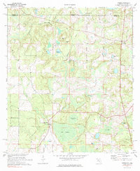
1973 Map of Gaskin
USGS Topo · Published 1985About this map
The Alabama-Florida state line defines the northern boundary of this Walton County landscape, where the settlements of Gaskin and Red Bay serve as local hubs in a terrain dominated by low-lying wetlands and creek systems. To the south, the vast expanse of Big Swamp and the Big Swamp Annex reveal a complex drainage network feeding into Caney Creek. Local life is anchored by landmarks such as the Eightmile Creek Ch and a strategic Lookout Tower positioned near the swamp's edge.
Find a feature on this map
26 named features on this map. Tap any name to fly to it.
Don’t see what you’re looking for? This feature index may not catch every label — zoom into the map to look around manually.
Map Details
Editions of this 1973 Gaskin Map
3 editions found
Other maps of this area

1949 · Glendale
USGS Topo · 1:62,500

1949 · Laurel Hill
USGS Topo · 1:62,500

1950 · Laurel Hill
USGS Topo · 1:62,500

1951 · Glendale
USGS Topo · 1:62,500

1953 · Andalusia
USGS Topo · 1:250,000

1957 · Andalusia
USGS Topo · 1:250,000

1957 · Pensacola
USGS Topo · 1:250,000

1959 · Pensacola
USGS Topo · 1:250,000

1960 · Pensacola
USGS Topo · 1:250,000
1968 · Samson
USGS Topo · 1:24,000