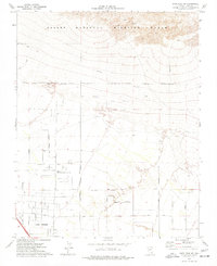
1974 Map of Gass Peak SW
USGS Topo · Published 1977About this map
The northern edge of Las Vegas meets the southern boundary of the Desert National Wildlife Range in this mid-1970s survey. The landscape transitions from the developed streets of the city to the alluvial fans and mountains of the wildlife range, marked by the prominent June Bug Mine in the northern hills. Along the Las Vegas Corporate Boundary, new infrastructure like Centennial Parkway, Ann Road, and Elkhorn Road defines the path of suburban expansion into the desert. The presence of the Home of the Good Shepherd church and a network of Jeep Trails heading into the wilderness reflects a community on the move. This map captures the specific moment when local landmarks like Rainbow Blvd and Jones Blvd began to carve out the modern city grid from the open basin floor.
Find a feature on this map
12 named features on this map. Tap any name to fly to it.
Don’t see what you’re looking for? This feature index may not catch every label — zoom into the map to look around manually.
Map Details
Editions of this 1974 Gass Peak SW Map
3 editions found
Other maps of this area

1907 · Las Vegas
USGS Topo · 1:250,000

1908 · Las Vegas
USGS Topo · 1:250,000

1952 · Corn Creek Springs
USGS Topo · 1:62,500

1952 · Gass Peak
USGS Topo · 1:62,500

1952 · Blue Diamond
USGS Topo · 1:62,500

1952 · Las Vegas
USGS Topo · 1:62,500

1954 · Las Vegas
USGS Topo · 1:250,000

1957 · Las Vegas
USGS Topo · 1:250,000

1959 · Las Vegas
USGS Topo · 1:250,000

1962 · Las Vegas
USGS Topo · 1:250,000