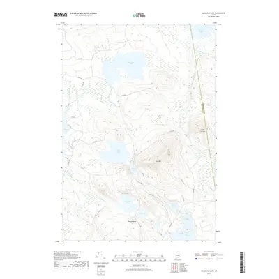
2018 Map of Gassabias Lake
USGS Topo · Published 2018About this map
Gassabias Lake and a complex network of glacial waterways define this portion of the Maine interior along the border of Washington and Hancock Counties. The landscape is dominated by significant elevations including Sabao Mtn and Fifth Lake Mtn, which overlook a series of interconnected basins such as Upper Sabao Lake and Lower Sabao Lake. The absence of established towns is notable, with the map showing an extensive system of forest roads, including Stud Mill Rd and various numbered routes like 37-00-0 RD, which facilitate movement through this remote timberland. Significant topographical features like Woodchopping Ridge and Horseshoe Mtn rise between the wetlands and drainage basins of Fifth Lake Stream and Coombs Brook, illustrating the challenging terrain of the Down East backcountry.
Find a feature on this map
41 named features on this map. Tap any name to fly to it.
Don’t see what you’re looking for? This feature index may not catch every label — zoom into the map to look around manually.
Map Details
Editions of this 2018 Gassabias Lake Map
This is the sole edition of this map. No revisions or reprints were ever made.
Other maps of this area

1929 · Lead Mountain
USGS Topo · 1:48,000

1932 · Nicatous Lake
USGS Topo · 1:48,000

1932 · Lead Mountain
USGS Topo · 1:62,500

1934 · Nicatous Lake
USGS Topo · 1:62,500

1941 · Tug Mountain
USGS Topo · 1:62,500

1941 · Wabassus Lake
USGS Topo · 1:62,500

1943 · Tug Mountain
USGS Topo · 1:62,500

1943 · Wabassus Lake
USGS Topo · 1:62,500

1948 · Bangor
USGS Topo · 1:250,000

1953 · Wabassus Lake
USGS Topo · 1:62,500