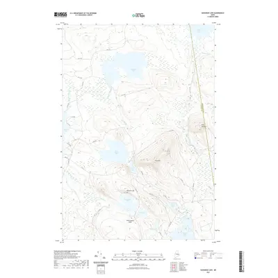
2021 Map of Gassabias Lake
USGS Topo · Published 2021About this map
Gassabias Lake and a complex network of glacial waterways define this portion of the Maine north woods near the boundary of Hancock and Washington counties. This interior landscape is characterized by its significant elevation changes, from the prominent Sabao Mtn and Fifth Lake Mtn to the low-lying wetlands surrounding Gassabias Stream and Drag Brook. The map reveals a highly specialized road system, including the well-known Stud Mill Rd, which supports the regional timber economy. The density of industrial forest roads such as 37-00-0 Rd and 32-00-0 Rd illustrates how logging infrastructure has integrated into the natural topography. For those interested in inland Maine hydrology, the connections between Upper Sabao Lake, Horseshoe Lake, and Burnt Land Lake provide a clear view of the drainage patterns essential to the local ecosystem.
Find a feature on this map
42 named features on this map. Tap any name to fly to it.
Don’t see what you’re looking for? This feature index may not catch every label — zoom into the map to look around manually.
Map Details
Editions of this 2021 Gassabias Lake Map
This is the sole edition of this map. No revisions or reprints were ever made.
Other maps of this area

1929 · Lead Mountain
USGS Topo · 1:48,000

1932 · Nicatous Lake
USGS Topo · 1:48,000

1932 · Lead Mountain
USGS Topo · 1:62,500

1934 · Nicatous Lake
USGS Topo · 1:62,500

1941 · Tug Mountain
USGS Topo · 1:62,500

1941 · Wabassus Lake
USGS Topo · 1:62,500

1943 · Tug Mountain
USGS Topo · 1:62,500

1943 · Wabassus Lake
USGS Topo · 1:62,500

1948 · Bangor
USGS Topo · 1:250,000

1953 · Wabassus Lake
USGS Topo · 1:62,500