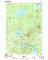
1987 Map of Gassabias Lake
USGS Topo · Published 1988About this map
Gassabias Lake and the surrounding unorganized townships of T 41 M D and T 35 M D characterize this interior Maine landscape during the late 1980s. The region is defined by an intricate network of glacial lakes and connective waterways, including Upper Sabao Lake and the southern reach of Fourth Machias Lake. High ground is marked by prominent landforms such as Sabao Mountain and the elongated Woodchopping Ridge, which overlook a series of smaller water bodies like Horseshoe Lake and Burnt Land Lake. The map captures the boundary line between Hancock and Washington counties, tracing a path through Fifth Lake Stream. This area remains largely defined by its lack of permanent settlements, focused instead on the natural hydrology and timberlands of the Down East interior. Researchers can trace the flow of Gassabias Stream as it connects the central lake to the western edge of the quadrangle near Nicatous Lake.
Find a feature on this map
25 named features on this map. Tap any name to fly to it.
Don’t see what you’re looking for? This feature index may not catch every label — zoom into the map to look around manually.
Map Details
Editions of this 1987 Gassabias Lake Map
This is the sole edition of this map. No revisions or reprints were ever made.
Other maps of this area

1929 · Lead Mountain
USGS Topo · 1:48,000

1932 · Nicatous Lake
USGS Topo · 1:48,000

1932 · Lead Mountain
USGS Topo · 1:62,500

1934 · Nicatous Lake
USGS Topo · 1:62,500

1941 · Tug Mountain
USGS Topo · 1:62,500

1941 · Wabassus Lake
USGS Topo · 1:62,500

1943 · Tug Mountain
USGS Topo · 1:62,500

1943 · Wabassus Lake
USGS Topo · 1:62,500

1948 · Bangor
USGS Topo · 1:250,000

1953 · Wabassus Lake
USGS Topo · 1:62,500