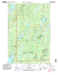
2005 Map of Gates Lake
USGS Topo · Published 2006About this map
Chequamegon-Nicolet National Forest encompasses the vast majority of this Price County landscape, defining a region where water and wetlands dictate the pattern of human use. The map reveals a complex aquatic network, from the Upper Squaw Creek Wetland Habitat Area to the distinctive Cranberry Bog in the northwest. These protected environments within the Squaw Creek Wildlife Management Area illustrate the 21st-century focus on conservation and managed recreation. Small recreational outposts like Hicks Landing and various boat ramps at Sailor Lake and Solberg Lake provide the primary points of access for locals and visitors alike. The terrain is further marked by the Medford Park Falls Ranger District, showcasing how forestry management and habitat preservation overlap in the town of Worcester.
Find a feature on this map
28 named features on this map. Tap any name to fly to it.
Don’t see what you’re looking for? This feature index may not catch every label — zoom into the map to look around manually.
Map Details
Editions of this 2005 Gates Lake Map
This is the sole edition of this map. No revisions or reprints were ever made.
Other maps of this area

1941 · Park Falls
USGS Topo · 1:48,000

1941 · Pike Lake
USGS Topo · 1:48,000

1941 · Phillips
USGS Topo · 1:48,000

1941 · Brantwood
USGS Topo · 1:48,000

1942 · Pike Lake
USGS Topo · 1:48,000

1943 · Park Falls
USGS Topo · 1:48,000

1943 · Philliips
USGS Topo · 1:48,000

1943 · Brantwood
USGS Topo · 1:48,000

1947 · Park Falls
USGS Topo · 1:48,000

1950 · Pike Lake
USGS Topo · 1:48,000