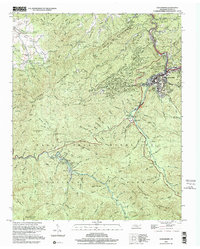
2000 Map of Gatlinburg
USGS Topo · Published 2001About this map
Gatlinburg serves as the focal point of this survey, where the concentrated development of Chalet Village and Greystone Heights meets the northern boundary of the Great Smoky Mountains National Park. The landscape is dominated by the steep rise of Cove Mountain and the deep drainage of the West Prong Little River, which dictates the path of the Parkway. Outside the primary tourist corridor, the map preserves evidence of older community life, including Starkeytown and several rural religious sites like Beech Grove Ch and Banner Ch.
Find a feature on this map
101 named features on this map. Tap any name to fly to it.
Don’t see what you’re looking for? This feature index may not catch every label — zoom into the map to look around manually.
Map Details
Editions of this 2000 Gatlinburg Map
This is the sole edition of this map. No revisions or reprints were ever made.
Other maps of this area

1886 · Knoxville
USGS Topo · 1:125,000

1892 · Knoxville
USGS Topo · 1:125,000

1893 · Mt Guyot
USGS Topo · 1:125,000

1894 · Knoxville
USGS Topo · 1:125,000

1895 · Knoxville
USGS Topo · 1:125,000

1901 · Knoxville
USGS Topo · 1:125,000

1912 · Mt Guyot
USGS Topo · 1:125,000

1935 · English Mountain
USGS Topo · 1:48,000

1935 · Walden Creek
USGS Topo · 1:24,000

1935 · Richardson Cove
USGS Topo · 1:24,000