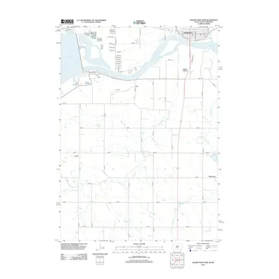
2012 Map of Gavins Point Dam
USGS Topo · Published 2012About this map
Gavins Point Dam and its expansive reservoir, Lewis and Clark Lake, dominate the boundary between South Dakota and Nebraska. This 2012 survey documents the civil engineering and recreational landscape surrounding Yankton, detailing the intricate street grid north of the Missouri River including W Riverside Dr and E Riverside Dr. South of the river, the Nebraska side features smaller communities like Aten and Menominee, connected by a network of rural roads that cross Beaver Cr and Antelope Cr. The map provides essential details for those studying the regional transition from the industrial Kaiser Ditch to conservation sites like the Gavins Point National Fish Hatchery. Notable landmarks for local history include Aten Cem and Beaver Creek Cem, while leisure interests are represented by the Lakeview Golf Course and South Shore Campground.
Find a feature on this map
64 named features on this map. Tap any name to fly to it.
Don’t see what you’re looking for? This feature index may not catch every label — zoom into the map to look around manually.
Map Details
Editions of this 2012 Gavins Point Dam Map
This is the sole edition of this map. No revisions or reprints were ever made.
Other maps of this area

1955 · Sioux City
USGS Topo · 1:250,000

1957 · Mission Hill
USGS Topo · 1:24,000

1958 · Sioux City
USGS Topo · 1:250,000

1959 · Sioux City
USGS Topo · 1:250,000

1968 · Tabor SE
USGS Topo · 1:24,000

1968 · Bloomfield NE
USGS Topo · 1:24,000

1968 · Gavins Point Dam
USGS Topo · 1:24,000

1968 · Crofton
USGS Topo · 1:24,000

1968 · Fordyce
USGS Topo · 1:24,000
1968 · Menominee
USGS Topo · 1:24,000