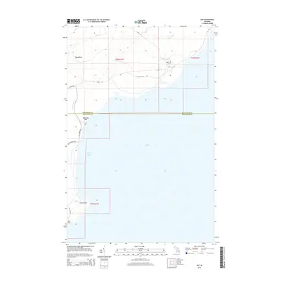
2014 Map of Gay
USGS Topo · Published 2014About this map
Gay and Snowshoe sit along the shoreline of Lake Superior in this remote stretch of Michigan's Keweenaw Peninsula. The landscape is defined by the sharp boundary between Keweenaw Co and Houghton Co, where the coastline curves from the mouth of the Tobacco River south toward Grand Traverse Bay. The geography transitions from the upland interior to prominent coastal features like Traverse Point and Louis Point. Local access is provided by thoroughfares such as Liminga Rd and Gay Rd, while more specialized routes like Pier Rd and Vehicle Trail 124 suggest the historical industrial and maritime significance of these small coastal settlements. The mapping of the Traverse River entering Traverse Bay highlights the essential relationship between the region's inland waterways and the expansive lake.
Find a feature on this map
21 named features on this map. Tap any name to fly to it.
Don’t see what you’re looking for? This feature index may not catch every label — zoom into the map to look around manually.
Map Details
Editions of this 2014 Gay Map
This is the sole edition of this map. No revisions or reprints were ever made.
Other maps of this area

1938 · Bruneau Creek
USGS Topo · 1:31,680

1938 · Gay
USGS Topo · 1:31,680

1939 · Deer Lake
USGS Topo · 1:31,680

1940 · Deer Lake
USGS Topo · 1:31,680

1941 · Mohawk
USGS Topo · 1:31,680

1946 · Bruneau Creek
USGS Topo · 1:24,000

1946 · Mohawk
USGS Topo · 1:24,000
1948 · Mohawk
USGS Topo · 1:24,000
1948 · Bruneau Creek
USGS Topo · 1:24,000
1948 · Deer Lake
USGS Topo · 1:24,000