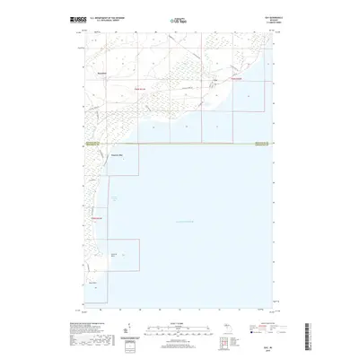
2019 Map of Gay
USGS Topo · Published 2019About this map
Gay stands at the northern edge of the Keweenaw Peninsula’s eastern shore, where the Tobacco River meets the cold waters of Lake Superior. This landscape is defined by its coastal orientation, with the settlement of Snowshoe situated further inland along a network of routes like the Mohawk-Gay Rd. The coastline itself is punctuated by prominent features such as Traverse Point and Louis Point, which frame the opening of Grand Traverse Bay. The mapping of this area illustrates a transition from the dense interior wetlands to the rocky shoreline, where historically significant coastal roads like Gay Park Rd and Coal Dock Rd trace the water's edge. The presence of the Big Traverse River flowing into the bay highlights the drainage patterns critical to the development of this Upper Peninsula region.
Find a feature on this map
28 named features on this map. Tap any name to fly to it.
Don’t see what you’re looking for? This feature index may not catch every label — zoom into the map to look around manually.
Map Details
Editions of this 2019 Gay Map
This is the sole edition of this map. No revisions or reprints were ever made.
Other maps of this area

1938 · Bruneau Creek
USGS Topo · 1:31,680

1938 · Gay
USGS Topo · 1:31,680

1939 · Deer Lake
USGS Topo · 1:31,680

1940 · Deer Lake
USGS Topo · 1:31,680

1941 · Mohawk
USGS Topo · 1:31,680

1946 · Bruneau Creek
USGS Topo · 1:24,000

1946 · Mohawk
USGS Topo · 1:24,000
1948 · Mohawk
USGS Topo · 1:24,000
1948 · Bruneau Creek
USGS Topo · 1:24,000
1948 · Deer Lake
USGS Topo · 1:24,000