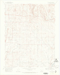
1968 Map of Gem Village
USGS Topo · Published 1972About this map
The Southern Ute Indian Reservation Boundary bisects this landscape, marking a transition between the northern high ground and the river valleys of the south. This late 1960s survey captures the area around Gem Village and Oxford during a period of transition, where traditional agriculture and newer infrastructure coexist. An extensive irrigation network, including the Consolidated Ditch, Pioneer Ditch, and Morrison Ditch, snakes across the terrain to support farming between the Florida River and the Los Pinos River. In the southern portion of the quadrangle, the Southern Ute Agency serves as a central hub near the community of Ignacio. The presence of a Drive-in Theater and the County Airport reflects mid-century development, while the Old Railroad Grade and numerous Gas Wells point to the region's evolving transportation and energy history.
Find a feature on this map
25 named features on this map. Tap any name to fly to it.
Don’t see what you’re looking for? This feature index may not catch every label — zoom into the map to look around manually.
Map Details
Editions of this 1968 Gem Village Map
2 editions found
Other maps of this area

1898 · Durango
USGS Topo · 1:62,500

1907 · Durango
USGS Topo · 1:62,500

1908 · Ignacio
USGS Topo · 1:125,000

1908 · Durango
USGS Topo · 1:62,500

1924 · Ignacio
USGS Topo · 1:125,000

1945 · Durango
USGS Topo · 1:250,000

1953 · Durango
USGS Topo · 1:250,000

1954 · Durango
USGS Topo · 1:250,000

1961 · Durango
USGS Topo · 1:250,000

1963 · Durango
USGS Topo · 1:250,000