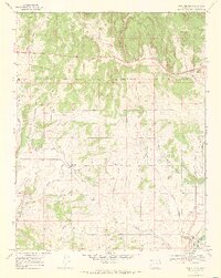
1968 Map of Gem Village
USGS Topo · Published 1972About this map
The Southern Ute Agency and the Southern Ute Indian Reservation Boundary anchor this late 1960s landscape in La Plata County. The map details a complex irrigation network vital to the high-desert economy, featuring the King Consolidated Ditch, Morrison Ditch, and Pioneer Ditch. While the Old Railroad Grade marks the former path of rail transport through the southern valleys, the modern era is represented by the County Airport and the Drive-in Theater near the junction of Ignacio Creek and Rock Creek. Settlement patterns are concentrated around Bayfield, Gem Village, and Oxford, while the southeastern corner focuses on the institutional and community presence at Ignacio. Local history and genealogy are supported by the mapping of the Chieftan Mem and Ouray Memorial Cem near Ute Park.
Find a feature on this map
34 named features on this map. Tap any name to fly to it.
Don’t see what you’re looking for? This feature index may not catch every label — zoom into the map to look around manually.
Map Details
Editions of this 1968 Gem Village Map
2 editions found
Other maps of this area

1898 · Durango
USGS Topo · 1:62,500

1907 · Durango
USGS Topo · 1:62,500

1908 · Ignacio
USGS Topo · 1:125,000

1908 · Durango
USGS Topo · 1:62,500

1924 · Ignacio
USGS Topo · 1:125,000

1945 · Durango
USGS Topo · 1:250,000

1953 · Durango
USGS Topo · 1:250,000

1954 · Durango
USGS Topo · 1:250,000

1961 · Durango
USGS Topo · 1:250,000

1963 · Durango
USGS Topo · 1:250,000