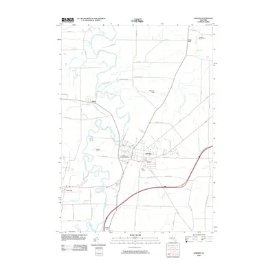
2010 Map of Geneseo
USGS Topo · Published 2010About this map
The State University of New York at Geneseo anchors this region of Livingston County, where the valley floor is defined by the winding course of the Genesee River. To the west, the village of Cuylerville and the hamlet of Piffard sit near the river's edge, while the upland areas to the east are marked by prominent water features such as Fall Brook Falls and Triphammer Falls. The landscape reflects a mix of institutional presence and rural heritage, with large parcels such as the Wadsworth Boy Scout Camp and the Geneseo Airport punctuating the grid of country roads. Local history is preserved at Temple Hill Cemetery and Saint Marys Cemetery near the heart of Geneseo. The drainage patterns of Beards Creek and Jaycox Creek illustrate the natural topography that shaped early settlement near Hampton Corners and South Avon.
Find a feature on this map
58 named features on this map. Tap any name to fly to it.
Don’t see what you’re looking for? This feature index may not catch every label — zoom into the map to look around manually.
Map Details
Editions of this 2010 Geneseo Map
This is the sole edition of this map. No revisions or reprints were ever made.
Other maps of this area

1901 · Honeoye
USGS Topo · 1:62,500

1902 · Wayland
USGS Topo · 1:62,500

1904 · Wayland
USGS Topo · 1:62,500

1904 · Caledonia
USGS Topo · 1:62,500

1904 · Honeoye
USGS Topo · 1:62,500

1905 · Nunda
USGS Topo · 1:62,500

1934 · Rush
USGS Topo · 1:24,000

1942 · Conesus
USGS Topo · 1:31,680
1942 · Livonia
USGS Topo · 1:31,680

1943 · Mount Morris
USGS Topo · 1:24,000