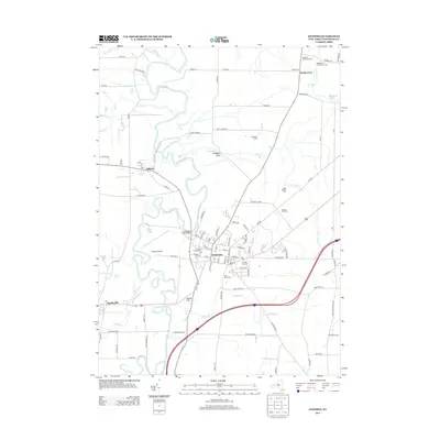
2013 Map of Geneseo
USGS Topo · Published 2013About this map
The Geneseo village core, centered on the campus of SUNY At Geneseo, anchors this study of the Genesee Valley. The landscape is defined by the winding course of the Genesee River, which creates a wide floodplain bordered by numerous creeks and ponds including Hemp Pond, Beards Cr, and Salt Cr. The map captures the agricultural and residential character of the region, featuring established farms such as Hideaway Farms and Hickory Hill Farm.
Find a feature on this map
95 named features on this map. Tap any name to fly to it.
Don’t see what you’re looking for? This feature index may not catch every label — zoom into the map to look around manually.
Map Details
Editions of this 2013 Geneseo Map
This is the sole edition of this map. No revisions or reprints were ever made.
Other maps of this area

1901 · Honeoye
USGS Topo · 1:62,500

1902 · Wayland
USGS Topo · 1:62,500

1904 · Wayland
USGS Topo · 1:62,500

1904 · Caledonia
USGS Topo · 1:62,500

1904 · Honeoye
USGS Topo · 1:62,500

1905 · Nunda
USGS Topo · 1:62,500

1934 · Rush
USGS Topo · 1:24,000

1942 · Conesus
USGS Topo · 1:31,680
1942 · Livonia
USGS Topo · 1:31,680

1943 · Mount Morris
USGS Topo · 1:24,000