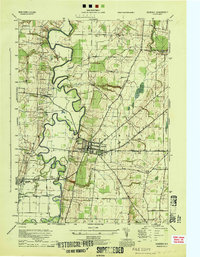
1944 Map of Geneseo
USGS Topo · Published 1944About this map
The Genesee River snakes in tight, dramatic oxbows across this mid-century landscape, dominating the valley floor between Geneseo and York Center. This 1944 War Department survey highlights the institutional and educational heart of the region at the State Normal School and the nearby Temple Hill Cem. The era's transportation network is clearly defined by the intersection of several major rail lines, including the Erie RR, Pennsylvania RR, and the G & W RR, which served the local industry and smaller hamlets like Piffard and Cuylerville. While the western portion of the sheet is defined by the alluvial flats of the river, the eastern section rises toward South Avon, dotted with numbered rural schoolhouses such as School No 1 and School No 9, reflecting the established district-school system of Livingston County during the wartime period.
Find a feature on this map
34 named features on this map. Tap any name to fly to it.
Don’t see what you’re looking for? This feature index may not catch every label — zoom into the map to look around manually.
Map Details
Editions of this 1944 Geneseo Map
This is the sole edition of this map. No revisions or reprints were ever made.
Other maps of this area

1901 · Honeoye
USGS Topo · 1:62,500

1902 · Wayland
USGS Topo · 1:62,500

1904 · Wayland
USGS Topo · 1:62,500

1904 · Caledonia
USGS Topo · 1:62,500

1904 · Honeoye
USGS Topo · 1:62,500

1905 · Nunda
USGS Topo · 1:62,500

1934 · Rush
USGS Topo · 1:24,000

1942 · Conesus
USGS Topo · 1:31,680
1942 · Livonia
USGS Topo · 1:31,680

1943 · Mount Morris
USGS Topo · 1:24,000