
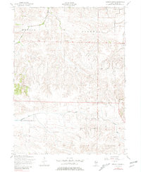
1953 Map of German Corner
USGS Topo · Published 1957About this map
German Corner sits at a rural crossroads in Henry County, Illinois, during the mid-1950s, representing a landscape defined by organized township boundaries and a network of agrarian institutions. The map reveals a high density of rural schools and churches that served as the social backbone for the townships of Munson, Cornwall, Cambridge, and Burns. Names such as Dublin School and Brandon School are documented alongside community centers like Liberty Church and State Road Church.
Find a feature on this map
17 named features on this map. Tap any name to fly to it.
Don’t see what you’re looking for? This feature index may not catch every label — zoom into the map to look around manually.
Map Details
Editions of this 1953 German Corner Map
2 editions found
Other maps of this area

1929 · Annawan
USGS Topo · 1:62,500

1931 · Galva
USGS Topo · 1:48,000

1932 · Annawan
USGS Topo · 1:62,500

1934 · Geneseo
USGS Topo · 1:62,500

1940 · Galva
USGS Topo · 1:62,500

1944 · Galva
USGS Topo · 1:62,500

1944 · Kewanee
USGS Topo · 1:62,500

1953 · Nekoma
USGS Topo · 1:24,000
1953 · Geneseo
USGS Topo · 1:24,000
1953 · Cambridge
USGS Topo · 1:24,000