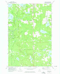
1972 Map of Germfask
USGS Topo · Published 1975About this map
The Manistique River winds through this region of Schoolcraft County, serving as the central artery for a landscape defined by conservation and forestry. In the early 1970s, the Seney National Wildlife Refuge dominated the western portion of the map, featuring a series of managed waterways including Upper Goose Pen Pool and Lower Goose Pen Pool. To the east, the Germfask State Forest covers large tracts of timberland, interwoven with a network of truck trails and jeep trails used for forest management and access to remote fishing spots like Stewart Lake and Crescent Lake. Genealogy researchers will find several significant burial sites, including the Old Germfask Cem and the Blaney Cem located near the southern boundary. The small settlement of Germfask remains the primary hub, situated near the Roadside Park and the local Germfask Ch.
Find a feature on this map
44 named features on this map. Tap any name to fly to it.
Don’t see what you’re looking for? This feature index may not catch every label — zoom into the map to look around manually.
Map Details
Editions of this 1972 Germfask Map
This is the sole edition of this map. No revisions or reprints were ever made.
Other maps of this area

1931 · Seney SW
USGS Topo · 1:31,680

1931 · Manistique River NE
USGS Topo · 1:31,680

1931 · Manistique River SE
USGS Topo · 1:31,680

1931 · Blaney SW
USGS Topo · 1:31,680

1931 · Seney SE
USGS Topo · 1:31,680

1931 · Blaney NE
USGS Topo · 1:31,680

1931 · Blaney SE
USGS Topo · 1:31,680

1931 · Blaney NW
USGS Topo · 1:31,680

1931 · Driggs Lake SE
USGS Topo · 1:31,680

1954 · Sault Sainte Marie
USGS Topo · 1:250,000