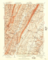
1937 Map of Gerrardstown
USGS Topo · Published 1957About this map
Gerrardstown and the surrounding Berkeley County landscape are defined by the parallel ridges of Sleepy Creek Mountain, Third Hill Mountain, and North Mountain. This 1930s-era topography reveals a complex network of rural institutions, including the Old Stone Church and Tuscarora Church, alongside numerous localized schoolhouses like McCubbin School and Sylvan Retreat School. The map captures the industrial and transit footprint of the period, from the Pennsylvania railroad line near Darkesville to the historic Braddock Road and the Tollgate near Inwood. Water crossings such as Warm Springs Ford and Baileys Ford along Back Creek indicate how residents navigated the valley floor between the high ridges. This survey provides a clear view of the transition from the rugged West Virginia heights into the more settled agricultural areas of the Shenandoah Valley borderlands.
Find a feature on this map
107 named features on this map. Tap any name to fly to it.
Don’t see what you’re looking for? This feature index may not catch every label — zoom into the map to look around manually.
Map Details
Editions of this 1937 Gerrardstown Map
3 editions found

Other maps of this area

1884 · Harpers Ferry
USGS Topo · 1:125,000

1891 · Harpers Ferry
USGS Topo · 1:125,000

1893 · Harpers Ferry
USGS Topo · 1:125,000

1894 · Winchester
USGS Topo · 1:125,000

1898 · Paw Paw
USGS Topo · 1:62,500

1899 · Hancock
USGS Topo · 1:62,500

1900 · Pawpaw
USGS Topo · 1:62,500

1901 · Hancock
USGS Topo · 1:62,500

1910 · Paw Paw
USGS Topo · 1:62,500

1912 · Williamsport
USGS Topo · 1:62,500