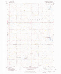
1973 Map of Gertson Slough
USGS Topo · Published 1978About this map
Gertson Slough and the winding Dolph Creek define this pocket of the eastern Dakotas, where the border of Hamlin and Kingsbury counties meets the town lines of Garfield, Cleveland, Hartland, and Badger. The landscape is a mix of agricultural section lines and significant conservation efforts, evidenced by multiple wildlife zones including the Harju State Public Shooting Area and the National Waterfowl Production Area. For local historians and genealogists, the map preserves the specific locations of rural community centers like the Garfield Church and three distinct burial grounds: Scandinavian Cemetery, Garfield Cemetery, and St Peters Cemetery. These features reflect the 19th-century settlement patterns of the region that persisted into the late 20th century.
Find a feature on this map
17 named features on this map. Tap any name to fly to it.
Don’t see what you’re looking for? This feature index may not catch every label — zoom into the map to look around manually.
Map Details
Editions of this 1973 Gertson Slough Map
This is the sole edition of this map. No revisions or reprints were ever made.
Other maps of this area

1953 · Watertown
USGS Topo · 1:250,000

1958 · Watertown
USGS Topo · 1:250,000

1968 · Lake Preston NE
USGS Topo · 1:24,000

1968 · Erwin
USGS Topo · 1:24,000

1968 · Badger
USGS Topo · 1:24,000

1969 · Hayti
USGS Topo · 1:24,000

1969 · Lake Norden
USGS Topo · 1:24,000

1973 · Bryant NE
USGS Topo · 1:24,000

1973 · Bryant
USGS Topo · 1:24,000

1973 · Vienna East
USGS Topo · 1:24,000