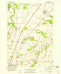
1957 Map of Gervais
USGS Topo · Published 1958About this map
The agricultural heart of French Prairie is defined here by the transit corridors of the Baldock Freeway and the Southern Pacific railroad, which anchor several small Willamette Valley communities in the mid-1950s. The settlement of Gervais serves as a local hub, featuring a concentrated grid of streets and the Sacred Heart Sch, while the southern portion of the map is dominated by the former lakebed of Lake Labish, now utilized for intensive farming.
Find a feature on this map
49 named features on this map. Tap any name to fly to it.
Don’t see what you’re looking for? This feature index may not catch every label — zoom into the map to look around manually.
Map Details
Editions of this 1957 Gervais Map
3 editions found
Other maps of this area

1915 · Eola
USGS Topo · 1:31,680

1917 · Salem
USGS Topo · 1:62,500

1923 · Mount Angel
USGS Topo · 1:62,500

1924 · Mc Minnville
USGS Topo · 1:48,000

1925 · Stayton
USGS Topo · 1:62,500

1926 · Mc Minnville
USGS Topo · 1:62,500

1940 · McMinnville
USGS Topo · 1:62,500

1940 · Salem
USGS Topo · 1:62,500

1940 · Mount Angel
USGS Topo · 1:62,500

1941 · Stayton
USGS Topo · 1:62,500