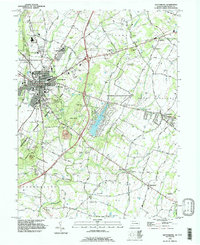
1990 Map of Gettysburg
USGS Topo · Published 1995About this map
The hallowed grounds of the Gettysburg National Military Park dominate this 1990 survey, showing the complex interplay of memorialization and local development at the close of the twentieth century. From the heights of Cemetery Hill and Culps Hill to the tactical terrain of Devils Den and Little Round Top, the map delineates the preservation of the battlefield against the evolving streetscapes of Gettysburg. While the town remains a hub of academic and civic life centered on Gettysburg College and the High Sch, the surrounding landscape of Cumberland and Mount Pleasant townships reveals a mix of agricultural heritage and modern expansion. Residential growth is evident near Lake Heritage, while older rural anchors like Two Taverns and the Hoffman Orphanage persist along the historic corridors of the Baltimore Pike and Emmitsburg Road.
Find a feature on this map
75 named features on this map. Tap any name to fly to it.
Don’t see what you’re looking for? This feature index may not catch every label — zoom into the map to look around manually.
Map Details
Editions of this 1990 Gettysburg Map
This is the sole edition of this map. No revisions or reprints were ever made.
Other maps of this area

1908 · Gettysburg
USGS Topo · 1:62,500

1909 · Fairfield
USGS Topo · 1:62,500

1911 · Taneytown
USGS Topo · 1:62,500

1911 · Emmitsburg
USGS Topo · 1:62,500

1942 · Gettysburg
USGS Topo · 1:125,000

1943 · Emmitsburg
USGS Topo · 1:62,500

1944 · Gettysburg
USGS Topo · 1:31,680

1944 · Mc Sherrystown
USGS Topo · 1:31,680

1944 · Littlestown
USGS Topo · 1:31,680

1944 · Arendtsville
USGS Topo · 1:31,680