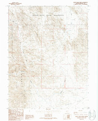
1987 Map of Ghost Dance Ridge
USGS Topo · Published 1988About this map
The Walker River Indian Reservation dominates the northern reaches of this Mineral County landscape, where the terrain climbs sharply into the high desert peaks of the Gillis Range. This 1987 provisional survey reveals a remote area defined by complex geological drainage systems, including Hu-Pui Wash, Ghost Dance Wash, and Wovoka Wash. The presence of several Prospects and a specific mineral survey point labeled Copper +6573 indicates an era of active prospecting and mining exploration in the mountains. South of the ridge line, the landscape opens into Buckley Flat, while narrow passages like Wildhorse Canyon and Gillis Canyon cut through the rugged slopes. The map also traces a network of 4wd tracks that provide the only access through this arid environment, connecting isolated mining claims to the broader basin.
Find a feature on this map
16 named features on this map. Tap any name to fly to it.
Don’t see what you’re looking for? This feature index may not catch every label — zoom into the map to look around manually.
Map Details
Editions of this 1987 Ghost Dance Ridge Map
This is the sole edition of this map. No revisions or reprints were ever made.
Other maps of this area

1909 · Hawthorne
USGS Topo · 1:250,000

1911 · Hawthorne
USGS Topo · 1:250,000

1915 · Hawthorne
USGS Topo · 1:250,000

1948 · Walker Lake
USGS Topo · 1:250,000

1955 · Hawthorne
USGS Topo · 1:62,500

1957 · Walker Lake
USGS Topo · 1:250,000

1962 · Walker Lake
USGS Topo · 1:250,000

1964 · Walker Lake
USGS Topo · 1:250,000

1964 · Gillis Canyon
USGS Topo · 1:62,500
1979 · Copper Mtn.
USGS Topo · 1:24,000