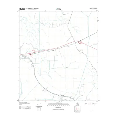
2012 Map of Gibson
USGS Topo · Published 2012About this map
Gibson and the surrounding wetlands of Terrebonne Parish are defined by a complex network of natural waterways and industrial infrastructure in the early 21st century. The landscape is dominated by the winding path of Bayou Black and Chacahoula Bayou, which are intersected by an extensive system of artificial waterways including the Donner Canal, Shell Canal, and the Terrebonne-Lafourche-Drainage-Canal. These drainage and navigation projects reflect the long-term management of this low-lying region.
Find a feature on this map
37 named features on this map. Tap any name to fly to it.
Don’t see what you’re looking for? This feature index may not catch every label — zoom into the map to look around manually.
Map Details
Editions of this 2012 Gibson Map
This is the sole edition of this map. No revisions or reprints were ever made.
Other maps of this area

1892 · Gibson
USGS Topo · 1:62,500

1892 · Thibodaux
USGS Topo · 1:62,500

1897 · Gibson
USGS Topo · 1:62,500

1932 · Thibodaux SE
USGS Topo · 1:31,680

1932 · Thibodaux SW
USGS Topo · 1:31,680

1935 · Morgan City
USGS Topo · 1:62,500

1938 · Labadieville
USGS Topo · 1:24,000
1938 · Lafourche
USGS Topo · 1:24,000

1939 · Gibson
USGS Topo · 1:62,500
1940 · Lafourche
USGS Topo · 1:31,680