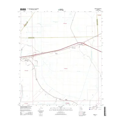
2015 Map of Gibson
USGS Topo · Published 2015About this map
Chacahoula Bayou and the winding Bayou Black define the low-lying terrain of this Terrebonne Parish landscape, where human settlement follows the higher ground alongside natural and man-made waterways. The small communities of Gibson, Donner, and Chacahoula are linked by a network of roads and rails that cut through a region heavily shaped by drainage efforts, including the massive Terrebonne Lafourche Drainage Canal and the Poinier Canal. These features highlight the ongoing engineering required to manage the coastal Louisiana environment.
Find a feature on this map
36 named features on this map. Tap any name to fly to it.
Don’t see what you’re looking for? This feature index may not catch every label — zoom into the map to look around manually.
Map Details
Editions of this 2015 Gibson Map
This is the sole edition of this map. No revisions or reprints were ever made.
Other maps of this area

1892 · Gibson
USGS Topo · 1:62,500

1892 · Thibodaux
USGS Topo · 1:62,500

1897 · Gibson
USGS Topo · 1:62,500

1932 · Thibodaux SE
USGS Topo · 1:31,680

1932 · Thibodaux SW
USGS Topo · 1:31,680

1935 · Morgan City
USGS Topo · 1:62,500

1938 · Labadieville
USGS Topo · 1:24,000
1938 · Lafourche
USGS Topo · 1:24,000

1939 · Gibson
USGS Topo · 1:62,500
1940 · Lafourche
USGS Topo · 1:31,680