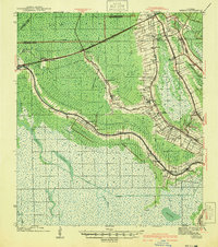
1941 Map of Gibson
USGS Topo · Published 1941About this map
Southern Pacific rail lines and winding bayous define this landscape in the early 1940s, where Louisiana's sugarcane and timber economies intersected. The map details a dense string of settlements and plantation-related sites along Bayou Black and Chacahoula Bayou, including Donner, Schriever, and the Beattleville Gray P O. This era is marked by active local institutions like the St Anthony Ch, Mt Pilgrim Ch, and the Magnolia Sch, reflecting the community structure of southern parishes. Significant industrial infrastructure is evident through the Intracoastal Waterway and traces of the Old Logging RR, while the southern expanse transitions into the marshes of Lake Hatch and Bayou Cocodrie. This survey serves as a vital record of the pre-modernization bayou country before many of these small schools and churches were consolidated or lost.
Find a feature on this map
62 named features on this map. Tap any name to fly to it.
Don’t see what you’re looking for? This feature index may not catch every label — zoom into the map to look around manually.
Map Details
Editions of this 1941 Gibson Map
This is the sole edition of this map. No revisions or reprints were ever made.
Other maps of this area

1892 · Lac Des Allemands
USGS Topo · 1:62,500

1892 · Gibson
USGS Topo · 1:62,500

1892 · Houma
USGS Topo · 1:62,500

1892 · Thibodaux
USGS Topo · 1:62,500

1894 · Bayou De Large
USGS Topo · 1:62,500

1894 · Dulac
USGS Topo · 1:62,500

1897 · Gibson
USGS Topo · 1:62,500

1932 · Lake Decade
USGS Topo · 1:62,500

1932 · Lac Des Allemands SW
USGS Topo · 1:31,680

1932 · Houma SW
USGS Topo · 1:31,680