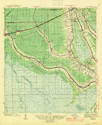
1944 Map of Gibson
USGS Topo · Published 1944About this map
Chacahoula Bayou and Bayou Black dictate the settlement patterns of this Louisiana delta landscape, where communities like Gibson and Donner grew alongside the Southern Pacific railroad line. The map reveals the intricate water management of the era, from the Intracoastal Waterway to a complex network of private and municipal canals including the Philip Canal and Hanson Canal. Local life is anchored by family and community landmarks such as Rose Hill Ch, Magnolia Sch, and the Beattieville Gray PO.
Find a feature on this map
70 named features on this map. Tap any name to fly to it.
Don’t see what you’re looking for? This feature index may not catch every label — zoom into the map to look around manually.
Map Details
Editions of this 1944 Gibson Map
This is the sole edition of this map. No revisions or reprints were ever made.
Other maps of this area

1892 · Lac Des Allemands
USGS Topo · 1:62,500

1892 · Gibson
USGS Topo · 1:62,500

1892 · Houma
USGS Topo · 1:62,500

1892 · Thibodaux
USGS Topo · 1:62,500

1894 · Bayou De Large
USGS Topo · 1:62,500

1894 · Dulac
USGS Topo · 1:62,500

1897 · Gibson
USGS Topo · 1:62,500

1932 · Lake Decade
USGS Topo · 1:62,500

1932 · Lac Des Allemands SW
USGS Topo · 1:31,680

1932 · Houma SW
USGS Topo · 1:31,680