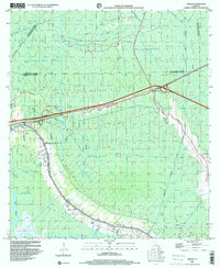
1998 Map of Gibson
USGS Topo · Published 2000About this map
Bayou Black serves as the central artery for this late-20th-century landscape, where the traditional water-based geography of the Louisiana bayous meets the industrial infrastructure of the Chacahola Oil and Gas Field. The settlement pattern follows the natural levees and rail lines, with the Southern Pacific railroad corridor linking the communities of Gibson and Donner. The map reveals a deeply working landscape, showing the transition from agricultural areas to modern petrochemical extraction, marked by numerous pipelines and gas wells. Local heritage is preserved in the placement of several historic congregations, including Rose Hill Ch and Beulah Ch, while the presence of an Indian Mound near Gibson points to much older human habitation. The extensive network of man-made waterways like the Phillips Canal and Donner Canal illustrates the ongoing effort to manage this subsidence-prone region.
Find a feature on this map
34 named features on this map. Tap any name to fly to it.
Don’t see what you’re looking for? This feature index may not catch every label — zoom into the map to look around manually.
Map Details
Editions of this 1998 Gibson Map
This is the sole edition of this map. No revisions or reprints were ever made.
Other maps of this area

1892 · Gibson
USGS Topo · 1:62,500

1892 · Thibodaux
USGS Topo · 1:62,500

1897 · Gibson
USGS Topo · 1:62,500

1932 · Thibodaux SE
USGS Topo · 1:31,680

1932 · Thibodaux SW
USGS Topo · 1:31,680

1935 · Morgan City
USGS Topo · 1:62,500

1938 · Labadieville
USGS Topo · 1:24,000
1938 · Lafourche
USGS Topo · 1:24,000

1939 · Gibson
USGS Topo · 1:62,500
1940 · Lafourche
USGS Topo · 1:31,680