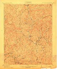
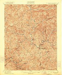
1912 Map of Gilbert
USGS Topo · Published 1912About this map
Guyandot River winds through a deeply dissected landscape at the intersection of Mingo, Logan, and Wyoming counties during the early twentieth century. The settlement of Gilbert serves as a central hub where Gilbert Creek meets the river, while the Norfolk and Western RR tracks follow the southern boundary along Tug Fork, connecting industrial outposts like Wharncliffe, War Eagle, and Glenalum Junc. The map reveals a coal-country topography defined by steep ridges and narrow hollows, such as Buffalo Mountain and Alum Creek Mountain.
Find a feature on this map
95 named features on this map. Tap any name to fly to it.
Don’t see what you’re looking for? This feature index may not catch every label — zoom into the map to look around manually.
Map Details
Editions of this 1912 Gilbert Map
2 editions found
Other maps of this area

1886 · Grundy
USGS Topo · 1:125,000

1887 · Warfield
USGS Topo · 1:125,000

1890 · Grundy
USGS Topo · 1:125,000

1891 · Tazewell
USGS Topo · 1:125,000

1891 · Oceana
USGS Topo · 1:125,000

1891 · Warfield
USGS Topo · 1:125,000

1892 · Grundy
USGS Topo · 1:125,000

1893 · Oceana
USGS Topo · 1:125,000

1895 · Tazewell
USGS Topo · 1:125,000

1897 · Tazewell
USGS Topo · 1:125,000