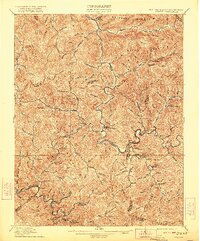
1912 Map of Gilbert
USGS Topo · Published 1922About this map
The Guyandot River carves a winding path through the coal-rich borderlands of West Virginia, Kentucky, and Virginia in this early twentieth-century survey. The landscape is defined by the high elevations of Buffalo Mountain and Huff Mountain, which separate the myriad drainages of Huff Creek and Gilbert Creek. Small riverside and valley settlements like Gilbert, Stafford, and Justice are established along the primary watercourses, while more remote outposts such as Hanover and North Spring sit deeper in the hollows.
Find a feature on this map
74 named features on this map. Tap any name to fly to it.
Don’t see what you’re looking for? This feature index may not catch every label — zoom into the map to look around manually.
Map Details
Editions of this 1912 Gilbert Map
2 editions found

Other maps of this area

1886 · Grundy
USGS Topo · 1:125,000

1887 · Warfield
USGS Topo · 1:125,000

1890 · Grundy
USGS Topo · 1:125,000

1891 · Tazewell
USGS Topo · 1:125,000

1891 · Oceana
USGS Topo · 1:125,000

1891 · Warfield
USGS Topo · 1:125,000

1892 · Grundy
USGS Topo · 1:125,000

1893 · Oceana
USGS Topo · 1:125,000

1895 · Tazewell
USGS Topo · 1:125,000

1897 · Tazewell
USGS Topo · 1:125,000