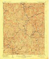
1925 Map of Gilbert
USGS Topo · Published 1925About this map
Guyandot River winds through the heart of this Appalachian coalfield landscape, anchoring settlements like Gilbert and Man during a period of industrial transition. The 1925 culture revision captures a dense network of local landmarks, particularly the numerous schools that served these mountain hollows, including the Craig Hatfield School and Jim Hatfield School. The arrival of heavy industry is evident in the rail infrastructure, with the Chesapeake and Ohio RR and Norfolk and Western RR carving paths through the steep terrain to reach mining operations at Glenalum and War Eagle. Genealogists will find particular value in the family-named features like Coon Knob and Jim Dolliver Br, which reflect the deep-rooted settlement patterns of the Mingo and Logan county lines before the later 20th-century shifts in the region's geography.
Find a feature on this map
147 named features on this map. Tap any name to fly to it.
Don’t see what you’re looking for? This feature index may not catch every label — zoom into the map to look around manually.
Map Details
Editions of this 1925 Gilbert Map
This is the sole edition of this map. No revisions or reprints were ever made.
Other maps of this area

1886 · Grundy
USGS Topo · 1:125,000

1887 · Warfield
USGS Topo · 1:125,000

1890 · Grundy
USGS Topo · 1:125,000

1891 · Tazewell
USGS Topo · 1:125,000

1891 · Oceana
USGS Topo · 1:125,000

1891 · Warfield
USGS Topo · 1:125,000

1892 · Grundy
USGS Topo · 1:125,000

1893 · Oceana
USGS Topo · 1:125,000

1895 · Tazewell
USGS Topo · 1:125,000

1897 · Tazewell
USGS Topo · 1:125,000