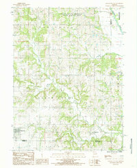
1984 Map of Gilman City East
USGS Topo · Published 1985About this map
Gilman City and Melbourne anchor the southwestern and southeastern corners of this 1980s landscape at the intersection of Harrison, Grundy, and Daviess counties. The terrain is defined by a dense network of meandering waterways, including Sugar Creek, Fox Creek, and the Thompson River in the northeast. The Wayne Helton Memorial State Wildlife Area dominates the northern section, preserving a significant portion of the natural timber and wetlands common to this part of Missouri. This survey captures a moment of transition between agricultural townships and protected conservation lands. Genealogists and local historians can trace the specific township boundaries of Lincoln, Sugar Creek, and Fox, which illustrate the organized land divisions that structured rural life in northern Missouri. The map provides a detailed view of the drainage patterns, where small tributaries like Tombstone Creek and Furnace Creek feed into the larger creek systems.
Find a feature on this map
18 named features on this map. Tap any name to fly to it.
Don’t see what you’re looking for? This feature index may not catch every label — zoom into the map to look around manually.
Map Details
Editions of this 1984 Gilman City East Map
This is the sole edition of this map. No revisions or reprints were ever made.
Other maps of this area

1925 · Gilman
USGS Topo · 1:62,500

1946 · Gilman
USGS Topo · 1:48,000

1946 · Princeton
USGS Topo · 1:62,500

1947 · Blythedale
USGS Topo · 1:62,500

1948 · Gilman
USGS Topo · 1:62,500

1948 · Princeton
USGS Topo · 1:62,500

1948 · Trenton
USGS Topo · 1:62,500

1954 · Centerville
USGS Topo · 1:250,000

1957 · Centerville
USGS Topo · 1:250,000

1958 · Centerville
USGS Topo · 1:250,000