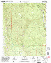
2002 Map of Gilman
USGS Topo · Published 2003About this map
The Guadalupe River and East Fork Jemez River converge near the settlement of Gilman, a landscape defined by significant land grants and tribal boundaries. This early 21st-century revision reveals the complex geography of the Cañon De San Diego Grant and the Jemez Indian Reservation, where massive mesas like Holiday Mesa and Guadalupe Mesa overlook deep canyons. The map records several vital water sources including Navajo Springs, Crow Springs, and Osha Spring, which have long sustained life in this high-elevation terrain. Dramatic geological features such as the Guadalupe Box and the heights of Pajarito Peak in the Sierra Nacimiento mark the western edge of the quadrangle. High-clearance 4wd tracks and forest roads provide the primary access through the Santa Fe National Forest, connecting remote landmarks like Deer Creek Landing to the lower Coyote Flats.
Find a feature on this map
76 named features on this map. Tap any name to fly to it.
Don’t see what you’re looking for? This feature index may not catch every label — zoom into the map to look around manually.
Map Details
Editions of this 2002 Gilman Map
This is the sole edition of this map. No revisions or reprints were ever made.
Other maps of this area

1890 · Jemes
USGS Topo · 1:125,000

1892 · Jemes
USGS Topo · 1:125,000

1937 · Jemez Springs
USGS Topo · 1:48,000

1939 · La Ventana
USGS Topo · 1:62,500

1939 · San Ysidro
USGS Topo · 1:62,500

1943 · San Ysidro
USGS Topo · 1:62,500

1943 · Jemez
USGS Topo · 1:62,500

1943 · La Ventana
USGS Topo · 1:62,500

1944 · Jemez Springs
USGS Topo · 1:62,500

1952 · Jemez Springs
USGS Topo · 1:62,500