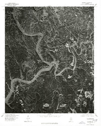
1975 Map of Gilmore
USGS Topo · Published 1977About this map
The Black Warrior River dominates this mid-1970s orthophotograph, marking the significant confluence where the Mulberry Fork and Locust Fork merge. This imagery, captured by the Geological Survey and the Soil Conservation Service, reveals a landscape defined by sharp ridge lines and deep river bends. The small settlement of Gilmore sits in the southeast, positioned away from the immediate riverbanks on higher ground. The map's photographic detail provides a clear look at the era's land-use patterns, showing the contrast between dense forest cover and cleared areas along the winding waterways. This specific vantage point highlights the dramatic hydrology of the region before further modern development altered the woodland character surrounding these major river forks.
Find a feature on this map
4 named features on this map. Tap any name to fly to it.
Don’t see what you’re looking for? This feature index may not catch every label — zoom into the map to look around manually.
Map Details
Editions of this 1975 Gilmore Map
This is the sole edition of this map. No revisions or reprints were ever made.
Other maps of this area

1893 · Jasper
USGS Topo · 1:125,000

1899 · Brookwood
USGS Topo · 1:125,000

1927 · Adger
USGS Topo · 1:48,000

1929 · Searles
USGS Topo · 1:48,000

1932 · Yolande
USGS Topo · 1:62,500

1934 · Searles
USGS Topo · 1:62,500

1935 · Port Birmingham
USGS Topo · 1:48,000

1935 · Yolande
USGS Topo · 1:62,500

1938 · Port Birmingham
USGS Topo · 1:62,500

1949 · Parrish
USGS Topo · 1:24,000