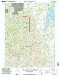
1996 Map of Gilmore Peak
USGS Topo · Published 2001About this map
Stonyford serves as a key gateway to the Mendocino National Forest, located at the edge of the rugged Indian Valley. The landscape is defined by the sharp rise of Gilmore Ridge and Gilmore Peak, which overlook the expansive East Park Reservoir to the east. The area's industrial past is marked by sites like the Ruby King Mine and the Gray Pine mining location near Little Stony Creek. The survey captures a mix of public and private land, including the Century Ranch and the resort-like Cooks Springs to the south. Local community infrastructure is well-documented, from the Stonyford Cem and Rodeo Grounds to the Stonyford Ranger Sta, alongside hydrological features such as a Diversion Canal and multiple gaging stations along Stony Creek.
Find a feature on this map
42 named features on this map. Tap any name to fly to it.
Don’t see what you’re looking for? This feature index may not catch every label — zoom into the map to look around manually.
Map Details
Editions of this 1996 Gilmore Peak Map
This is the sole edition of this map. No revisions or reprints were ever made.
Other maps of this area

1920 · Venado
USGS Topo · 1:62,500

1924 · Bartlett Springs
USGS Topo · 1:62,500

1942 · Bartlett Springs
USGS Topo · 1:62,500

1943 · Lodoga
USGS Topo · 1:62,500

1944 · Bartlett Springs
USGS Topo · 1:62,500

1944 · Wilbur Springs
USGS Topo · 1:62,500

1951 · Stonyford
USGS Topo · 1:62,500

1957 · Ukiah
USGS Topo · 1:250,000

1960 · Ukiah
USGS Topo · 1:250,000
1960 · Clearlake Oaks
USGS Topo · 1:62,500