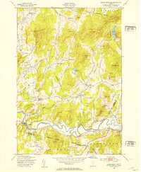
1948 Map of Gilson Mountain
USGS Topo · Published 1953About this map
The Lamoille River meanders across the southern portion of this landscape, anchoring a series of small agricultural and milling communities in the years following World War II. The terrain is defined by numerous family-named peaks such as Coombs Hill, Leach Hill, and Armstrong Mountain, which overlook a network of rural schoolhouses and local burying grounds. The map captures a transitional moment for these northern Vermont towns, where traditional landmarks like Buck Hollow Sch and Fletcher Cem remained vital to the community fabric. Several industrial sites are noted, including a quarry near the village of Fairfax Falls and another north of West Fletcher, indicating the local extraction economy of the mid-20th century. The intricate placement of roads connecting Binghamville and Huntsville illustrates the historical settlement patterns before major highway developments altered the rural character of Franklin and Lamoille Counties.
Find a feature on this map
52 named features on this map. Tap any name to fly to it.
Don’t see what you’re looking for? This feature index may not catch every label — zoom into the map to look around manually.
Map Details
Editions of this 1948 Gilson Mountain Map
4 editions found
Other maps of this area

1913 · Milton
USGS Topo · 1:48,000

1914 · St. Albans
USGS Topo · 1:48,000

1915 · Milton
USGS Topo · 1:62,500

1916 · St. Albans
USGS Topo · 1:62,500

1920 · Franklin Pond
USGS Topo · 1:62,500

1922 · Enosburg Falls
USGS Topo · 1:48,000

1924 · Enosburg Falls
USGS Topo · 1:62,500

1925 · Mount Mansfield
USGS Topo · 1:48,000

1927 · Mount Mansfield
USGS Topo · 1:62,500

1943 · St. Albans
USGS Topo · 1:62,500