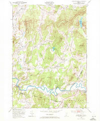
1948 Map of Gilson Mountain
USGS Topo · Published 1972About this map
Lamoille River meanders across the southern landscape of this 1948 survey, anchoring a region of dairy farms and timbered hills where Franklin, Lamoille, and Chittenden counties meet. The settlement of Fletcher and its outlying hamlets like Binghamville and West Fletcher are connected by a network of rural roads that navigate around significant elevations such as Gilson Mountain and Buck Mountain. Evidence of early community life is preserved through numerous rural schoolhouses, including Buck Hollow Sch and Parsons Sch, alongside local landmarks like Sanderson Cem.
Find a feature on this map
52 named features on this map. Tap any name to fly to it.
Don’t see what you’re looking for? This feature index may not catch every label — zoom into the map to look around manually.
Map Details
Editions of this 1948 Gilson Mountain Map
4 editions found
Other maps of this area

1913 · Milton
USGS Topo · 1:48,000

1914 · St. Albans
USGS Topo · 1:48,000

1915 · Milton
USGS Topo · 1:62,500

1916 · St. Albans
USGS Topo · 1:62,500

1920 · Franklin Pond
USGS Topo · 1:62,500

1922 · Enosburg Falls
USGS Topo · 1:48,000

1924 · Enosburg Falls
USGS Topo · 1:62,500

1925 · Mount Mansfield
USGS Topo · 1:48,000

1927 · Mount Mansfield
USGS Topo · 1:62,500

1943 · St. Albans
USGS Topo · 1:62,500