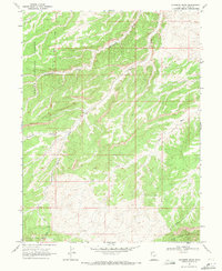
1968 Map of Gilsonite Draw
USGS Topo · Published 1971About this map
The Old Indian Treaty Boundary slices through this high desert landscape, marking a significant historical line of demarcation across the Duchesne County terrain. Established through field checks in the late 1960s, the map reveals a rugged geography defined by the Bad Land Cliffs to the south and the drainage systems of Gilsonite Draw and Wells Draw. The western edge is dominated by the Ashley National Forest, while the interior shows the subtle marks of resource exploration and infrastructure, including a scattered Drill Hole and a prominent Pipeline. This survey captures a moment when the land was utilized for both conservation and industry, interconnected by a network of rudimentary Jeep Trails navigating between Fivemile Canyon and the broad Big Wash.
Find a feature on this map
10 named features on this map. Tap any name to fly to it.
Don’t see what you’re looking for? This feature index may not catch every label — zoom into the map to look around manually.
Map Details
Editions of this 1968 Gilsonite Draw Map
2 editions found
Other maps of this area

1885 · Uinta
USGS Topo · 1:250,000

1886 · Price River
USGS Topo · 1:250,000

1896 · Price River
USGS Topo · 1:250,000

1939 · Duchesne
USGS Topo · 1:125,000

1954 · Salt Lake City
USGS Topo · 1:250,000

1956 · Price
USGS Topo · 1:250,000

1958 · Salt Lake City
USGS Topo · 1:250,000

1960 · Salt Lake City
USGS Topo · 1:250,000

1960 · Price
USGS Topo · 1:250,000

1962 · Price
USGS Topo · 1:250,000