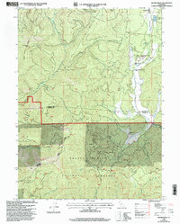
1998 Map of Girard Ridge
USGS Topo · Published 2003About this map
Shasta - Trinity National Forests land dominates this landscape, where the Pacific Crest National Scenic Trail winds through high-elevation terrain. This late-1990s revision reveals a pocket of recreation and small-scale settlement concentrated along the eastern edge within Squaw Valley. Here, the Cooley Circle Seven Ranch Resort and Cooley Circle Seven Ranch Recreation Site appear alongside the McCloud Golf Club RR. The topography is defined by the prominent Girard Ridge and several watercourses, including Soda Creek and McCloud Creek. A small Cem and a Mobile Home Park are noted near the Soda Springs area, while the interior forest is marked by remote landmarks such as the Willow Creek Ranch and various Communication Facilities. The county line between Siskiyou Co and Shasta Co cuts through the center of the survey.
Find a feature on this map
37 named features on this map. Tap any name to fly to it.
Don’t see what you’re looking for? This feature index may not catch every label — zoom into the map to look around manually.
Map Details
Editions of this 1998 Girard Ridge Map
This is the sole edition of this map. No revisions or reprints were ever made.
Other maps of this area

1886 · Shasta
USGS Topo · 1:250,000

1894 · Shasta
USGS Topo · 1:250,000

1935 · Dunsmuir
USGS Topo · 1:125,000

1948 · Weed
USGS Topo · 1:250,000

1950 · Weed
USGS Topo · 1:250,000

1954 · Shoeinhorse Mountain
USGS Topo · 1:62,500

1954 · Shasta
USGS Topo · 1:62,500

1954 · Weed
USGS Topo · 1:62,500

1954 · Dunsmuir
USGS Topo · 1:62,500

1958 · Weed
USGS Topo · 1:250,000