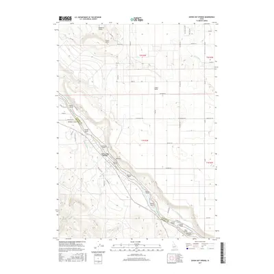
2017 Map of Givens Hot Springs
USGS Topo · Published 2017About this map
Givens Hot Springs serves as a focal point along the southwestern bank of the Snake River, where the landscape is defined by the transition from irrigated valley floors to the rising terrain of Pickles Butte. This 2017 survey details a complex network of water management essential to the region's agricultural character, including the Deer Flat Low Line Canal, Opalene Ditch, and Nicholson Ditch. The river itself is punctuated by numerous named landforms such as Blackburn Island, Dredge Island, and Rippee Island, indicating a dynamic riparian environment where the Canyon Co Owyhee Co border follows the water's path.
Find a feature on this map
60 named features on this map. Tap any name to fly to it.
Don’t see what you’re looking for? This feature index may not catch every label — zoom into the map to look around manually.
Map Details
Editions of this 2017 Givens Hot Springs Map
This is the sole edition of this map. No revisions or reprints were ever made.
Other maps of this area

1892 · Silver City
USGS Topo · 1:125,000

1894 · Silver City
USGS Topo · 1:125,000

1898 · Nampa
USGS Topo · 1:125,000

1898 · Silver City
USGS Topo · 1:125,000

1955 · Boise
USGS Topo · 1:250,000
1957 · Walters Butte
USGS Topo · 1:24,000

1957 · Opalene Gulch
USGS Topo · 1:24,000

1957 · Wilson Peak
USGS Topo · 1:24,000

1957 · Sands Basin
USGS Topo · 1:62,500

1958 · Boise
USGS Topo · 1:250,000