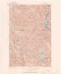
1899 Map of Glacier Peak
USGS Topo · Published 1963About this map
Glacier Peak dominates this 1890s survey of the high North Cascades, documenting the region's early mining activity and natural geography long before the establishment of modern wilderness protections. The map traces the upper reaches of the Cascade River, Stehekin River, and the White Chuck River, where small outposts like Mineral Park and Bedal served as remote bases for prospectors. High-altitude landmarks such as Miners Ridge and Monte Cristo Lake indicate the era's focus on mineral wealth in the surrounding Mt. Baker National Forest and Wenatchee National Forest.
Find a feature on this map
106 named features on this map. Tap any name to fly to it.
Don’t see what you’re looking for? This feature index may not catch every label — zoom into the map to look around manually.
Map Details
Editions of this 1899 Glacier Peak Map
2 editions found
Other maps of this area

1899 · Glacier Peak
USGS Topo · 1:125,000

1899 · Stillaguamish
USGS Topo · 1:125,000

1901 · Glacier Peak
USGS Topo · 1:125,000

1901 · Stilaguamish
USGS Topo · 1:125,000

1901 · Chiwaukum
USGS Topo · 1:125,000

1902 · Skykomish
USGS Topo · 1:125,000

1902 · Stehekin
USGS Topo · 1:125,000

1904 · Stehekin
USGS Topo · 1:125,000

1904 · Chiwaukum
USGS Topo · 1:125,000

1905 · Skykomish
USGS Topo · 1:125,000