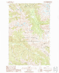
1988 Map of Glacier Peak West
USGS Topo · Published 1988About this map
Kennedy Hot Spring and the Pacific Crest National Scenic Trail anchor this 1988 survey of the Cascades, where the Snohomish and Chelan county line traverses high alpine terrain. This area is defined by the convergence of the Glacier Peak Wilderness, Henry M Jackson Wilderness, and the Mt Baker National Forest. The landscape is a network of glacial activity and volcanic geology, evidenced by the White Chuck Cinder Cone and numerous ice fields including the Sitkum Glacier and Scimitar Glacier.
Find a feature on this map
37 named features on this map. Tap any name to fly to it.
Don’t see what you’re looking for? This feature index may not catch every label — zoom into the map to look around manually.
Map Details
Editions of this 1988 Glacier Peak West Map
This is the sole edition of this map. No revisions or reprints were ever made.
Other maps of this area

1899 · Glacier Peak
USGS Topo · 1:125,000

1901 · Glacier Peak
USGS Topo · 1:125,000

1902 · Skykomish
USGS Topo · 1:125,000

1905 · Skykomish
USGS Topo · 1:125,000

1950 · Glacier Peak
USGS Topo · 1:62,500

1955 · Concrete
USGS Topo · 1:250,000

1957 · Wenatchee
USGS Topo · 1:250,000

1958 · Concrete
USGS Topo · 1:250,000

1962 · Concrete
USGS Topo · 1:250,000

1965 · Poe Mountain
USGS Topo · 1:24,000