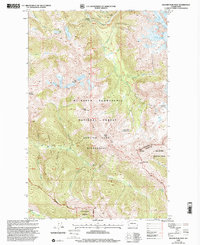
1999 Map of Glacier Peak West
USGS Topo · Published 2002About this map
The Pacific Crest National Scenic Trail winds through the high alpine passes of the Cascade Range, marking a critical corridor through the Mt Baker - Snoqualmie National Forest. This landscape is defined by its dramatic glacial activity, including the White Chuck Glacier, Sitkum Glacier, and Scimitar Glacier, which feed the headwaters of the White Chuck River and the Sauk River. Historically significant backcountry landmarks such as Mackinaw Shelter and the Kennedy Hot Spring are located within the remote Glacier Peak Wilderness. These features illustrate the area's long-standing role as a destination for wilderness travel and high-altitude navigation. The map also delineates the high-elevation divide at White Pass and Red Pass, where the border between Snohomish Co and Chelan Co follows the jagged ridgeline near White Mountain. Small alpine bodies of water like Lake Byrne and Hardtack Lake dot the terrain, offering a look at the drainage patterns that characterize this glaciated environment.
Find a feature on this map
37 named features on this map. Tap any name to fly to it.
Don’t see what you’re looking for? This feature index may not catch every label — zoom into the map to look around manually.
Map Details
Editions of this 1999 Glacier Peak West Map
This is the sole edition of this map. No revisions or reprints were ever made.
Other maps of this area

1899 · Glacier Peak
USGS Topo · 1:125,000

1901 · Glacier Peak
USGS Topo · 1:125,000

1902 · Skykomish
USGS Topo · 1:125,000

1905 · Skykomish
USGS Topo · 1:125,000

1950 · Glacier Peak
USGS Topo · 1:62,500

1955 · Concrete
USGS Topo · 1:250,000

1957 · Wenatchee
USGS Topo · 1:250,000

1958 · Concrete
USGS Topo · 1:250,000

1962 · Concrete
USGS Topo · 1:250,000

1965 · Poe Mountain
USGS Topo · 1:24,000