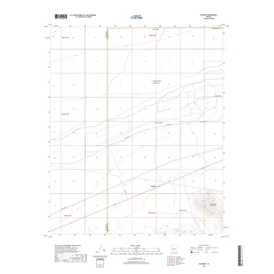
2018 Map of Gladden
USGS Topo · Published 2018About this map
Gladden sits at a crossroads of the Arizona desert, where the transition between the Aguila Valley and McMullen Valley creates a distinctive agricultural and topographic profile. The southern reaches of this landscape are dominated by the rising slopes of the Harquahala Mountains and the drainage of Dushey Canyon, contrasting with the engineered water management systems found further north. Several named irrigation channels, including Irrigation Acc, reflect the region's reliance on water infrastructure to support its rural economy. The presence of rural routes like Urea Ranch Rd and Eagle Eye Rd indicates the spread of ranching and remote residences through the desert flats, while the La Paz Co Maricopa Co boundary line provides a precise marker for genealogical researchers tracking historical property locations near the county line.
Find a feature on this map
17 named features on this map. Tap any name to fly to it.
Don’t see what you’re looking for? This feature index may not catch every label — zoom into the map to look around manually.
Map Details
Editions of this 2018 Gladden Map
This is the sole edition of this map. No revisions or reprints were ever made.
Other maps of this area
1923 · Signal
USGS Topo · 1:250,000
1942 · Signal
USGS Topo · 1:250,000
1942 · Vicksburg
USGS Topo · 1:250,000
1950 · Prescott
USGS Topo · 1:250,000
1954 · Prescott
USGS Topo · 1:250,000
1954 · Phoenix
USGS Topo · 1:250,000
1957 · Phoenix
USGS Topo · 1:250,000
1958 · Prescott
USGS Topo · 1:250,000
1958 · Phoenix
USGS Topo · 1:250,000
1959 · Prescott
USGS Topo · 1:250,000