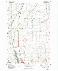
1992 Map of Glade
USGS Topo · Published 1992About this map
Esquatzel Coulee cuts a deep path through this Franklin County landscape, serving as a corridor for both natural drainage and the Burlington Northern Railroad. In the south, the city of Pasco pushes northward toward the Pasco Corporate Boundary, anchored by the Tri-Cities Airport and Columbia Basin Comm College. The settlement of Glade sits along the coulee's edge, surrounded by a grid of named rural roads like Phend Road and East Vineyard Drive.
Find a feature on this map
40 named features on this map. Tap any name to fly to it.
Don’t see what you’re looking for? This feature index may not catch every label — zoom into the map to look around manually.
Map Details
Editions of this 1992 Glade Map
This is the sole edition of this map. No revisions or reprints were ever made.
Other maps of this area

1915 · Wallulah
USGS Topo · 1:96,000

1917 · Pasco
USGS Topo · 1:125,000

1918 · Wallula
USGS Topo · 1:125,000

1953 · Walla Walla
USGS Topo · 1:250,000

1958 · Walla Walla
USGS Topo · 1:250,000

1963 · Rye Grass Coulee
USGS Topo · 1:24,000

1964 · Levey SW
USGS Topo · 1:24,000

1964 · Humorist
USGS Topo · 1:24,000

1964 · Kennewick
USGS Topo · 1:24,000

1964 · Pasco
USGS Topo · 1:62,500