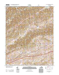
2013 Map of Glade Spring
USGS Topo · Published 2013About this map
Saltville anchors the northern portion of this survey, where the N Fork Holston River winds through a landscape defined by deep hollows and prominent ridges. To the south, the terrain opens into a corridor of established communities and transportation routes including Meadowview, Emory, and Glade Spring. This area reflects a long-standing settlement pattern along the Lee Hwy and Hillman Hwy, with older rural centers like Old Glade Spring positioned near the modern highway networks.
Find a feature on this map
109 named features on this map. Tap any name to fly to it.
Don’t see what you’re looking for? This feature index may not catch every label — zoom into the map to look around manually.
Map Details
Editions of this 2013 Glade Spring Map
This is the sole edition of this map. No revisions or reprints were ever made.
Other maps of this area

1891 · Abingdon
USGS Topo · 1:125,000

1894 · Abingdon
USGS Topo · 1:125,000

1909 · Abingdon
USGS Topo · 1:96,000

1911 · Abingdon
USGS Topo · 1:125,000

1935 · Konnarock
USGS Topo · 1:24,000

1935 · Chilhowie
USGS Topo · 1:24,000
1935 · Maccrady
USGS Topo · 1:24,000
1935 · Abingdon
USGS Topo · 1:24,000

1935 · Mount Rogers
USGS Topo · 1:48,000
1935 · Saltville
USGS Topo · 1:24,000