
1956 Map of Glades
USGS Topo · Published 1957About this map
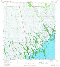
Everglades National Park dominates this mid-century survey, illustrating the complex intersection of subtropical wetlands and the expanding transportation infrastructure of South Florida. The transition from terrestrial glades to coastal waters is clearly defined by a series of points and keys including Narrow Point, Flat Point, and Middle Key. These features separate the interior marshlands from the expansive waters of Manatee Bay and Barnes Sound.
Find a feature on this map
13 named features on this map. Tap any name to fly to it.
Don’t see what you’re looking for? This feature index may not catch every label — zoom into the map to look around manually.
Map Details
Editions of this 1956 Glades Map
4 editions found

Other maps of this area

1947 · Garden Cove
USGS Topo · 1:24,000

1947 · Blackwater Sound
USGS Topo · 1:24,000

1949 · Blackwater Sound
USGS Topo · 1:24,000

1949 · Garden Cove
USGS Topo · 1:24,000

1949 · Card Sound
USGS Topo · 1:24,000

1949 · Arsenicker Keys
USGS Topo · 1:24,000

1950 · Homestead
USGS Topo · 1:24,000

1950 · Glades
USGS Topo · 1:24,000

1956 · Card Sound
USGS Topo · 1:24,000

1956 · Homestead
USGS Topo · 1:24,000