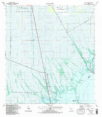
1988 Map of Glades
USGS Topo · Published 1988About this map
The Everglades National Park and Biscayne Bay Aquatic Preserve dominate this coastal landscape at the intersection of fresh and salt water environments. The southern tip of the Florida mainland is defined here by an intricate network of drainage systems, including the Aerojet Canal No C-111 and Model Land Canal South, which demonstrate the intensive hydrological engineering of the region. The map captures a transition from the structured infrastructure of the Dade Correctional Institute and the U S Naval Reservation to the open waters of Barnes Sound and Manatee Bay. Small landforms such as Narrow Point, Barnes Point, and Middle Key provide fine-scale reference points along the shoreline. Human activity is concentrated along the South Dixie Highway and Card Sound Road, while a Quarry and various radio facilities indicate the industrial and communication needs of the area during the late 1980s.
Find a feature on this map
29 named features on this map. Tap any name to fly to it.
Don’t see what you’re looking for? This feature index may not catch every label — zoom into the map to look around manually.
Map Details
Editions of this 1988 Glades Map
2 editions found
Other maps of this area

1947 · Garden Cove
USGS Topo · 1:24,000

1947 · Blackwater Sound
USGS Topo · 1:24,000

1949 · Blackwater Sound
USGS Topo · 1:24,000

1949 · Garden Cove
USGS Topo · 1:24,000

1949 · Card Sound
USGS Topo · 1:24,000

1949 · Arsenicker Keys
USGS Topo · 1:24,000

1950 · Homestead
USGS Topo · 1:24,000

1950 · Glades
USGS Topo · 1:24,000

1956 · Card Sound
USGS Topo · 1:24,000

1956 · Homestead
USGS Topo · 1:24,000