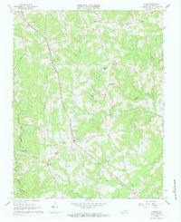
1966 Map of Gladys
USGS Topo · Published 1984About this map
The Norfolk and Western railroad corridor serves as the primary artery through this section of Campbell County, Virginia, anchoring several small rural communities during the mid-1960s. The village of Gladys serves as a central hub, featuring the Gladys Sch and a local substation, while further north, the community of Winfall marks a significant bend in the rail line. This landscape is defined by its numerous rural congregations, including St Stephens Ch, First St Pauls Ch, and Wesleybury Ch, reflecting the dense social fabric of the Piedmont region.
Find a feature on this map
28 named features on this map. Tap any name to fly to it.
Don’t see what you’re looking for? This feature index may not catch every label — zoom into the map to look around manually.
Map Details
Editions of this 1966 Gladys Map
Other maps of this area

1892 · Lynchburg
USGS Topo · 1:125,000

1892 · Appomattox
USGS Topo · 1:125,000

1944 · Lynchburg
USGS Topo · 1:62,500

1947 · Roanoke
USGS Topo · 1:250,000

1950 · Lynchburg
USGS Topo · 1:62,500

1956 · Brookneal
USGS Topo · 1:62,500

1956 · Gladys
USGS Topo · 1:62,500

1958 · Appomattox
USGS Topo · 1:62,500

1959 · Roanoke
USGS Topo · 1:250,000

1963 · Roanoke
USGS Topo · 1:250,000