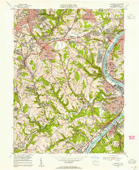
1953 Map of Glassport
USGS Topo · Published 1955About this map
Industrial hubs and suburban expansion characterize this southern Allegheny County landscape as captured in the early 1950s. The Monongahela River serves as the primary artery for heavy industry, with the dense riverside settlements of Clairton, Glassport, and Elizabeth showing a complex weave of rail lines and shorefront facilities. Further inland, the map documents the post-war growth of residential communities like Brentwood, Whitehall, and Pleasant Hills.
Find a feature on this map
78 named features on this map. Tap any name to fly to it.
Don’t see what you’re looking for? This feature index may not catch every label — zoom into the map to look around manually.
Map Details
Editions of this 1953 Glassport Map
This is the sole edition of this map. No revisions or reprints were ever made.
Other maps of this area

1901 · Amity
USGS Topo · 1:62,500

1902 · Brownsville
USGS Topo · 1:62,500

1904 · Amity
USGS Topo · 1:62,500

1904 · Mc Keesport
USGS Topo · 1:62,500

1904 · Carnegie
USGS Topo · 1:62,500

1906 · Brownsville
USGS Topo · 1:62,500

1906 · Carnegie
USGS Topo · 1:62,500

1907 · Pittsburg
USGS Topo · 1:62,500

1908 · Carnegie
USGS Topo · 1:62,500

1931 · Brownsville
USGS Topo · 1:62,500