
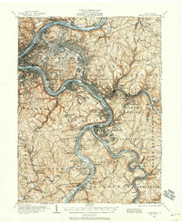
1904 Map of Mc Keesport
USGS Topo · Published 1904About this map
The Monongahela River and Allegheny River valley systems define this industrial heartland, showing the intense concentration of steel-era settlements and infrastructure at the start of the 20th century. Major municipal green spaces like Schenley Park and Highland Park offer a striking contrast to the dense rail networks of the Pennsylvania RR and the Baltimore and Ohio RR that hug the riverbanks. The map documents the growth of residential and industrial hubs from Wilkinsburg and Homestead to the vital junctions at Braddock and Turtle Creek.
Find a feature on this map
138 named features on this map. Tap any name to fly to it.
Don’t see what you’re looking for? This feature index may not catch every label — zoom into the map to look around manually.
Map Details
Editions of this 1904 Mc Keesport Map
2 editions found
Other maps of this area

1901 · Amity
USGS Topo · 1:62,500

1902 · Brownsville
USGS Topo · 1:62,500

1902 · Connellsville
USGS Topo · 1:62,500

1904 · Amity
USGS Topo · 1:62,500

1904 · Carnegie
USGS Topo · 1:62,500

1904 · Greensburg
USGS Topo · 1:62,500

1906 · Brownsville
USGS Topo · 1:62,500

1906 · Carnegie
USGS Topo · 1:62,500

1906 · Greensburg
USGS Topo · 1:62,500

1906 · Sewickley
USGS Topo · 1:62,500